
MAKAW INDIAN TRIBE ....
Located at the most NORTH WEST POINT OF LAND of the "Lower" 48 States in the State of WASHINGTON ... on the SOUTHERN Shore of The Straits of JUAN de FUCA ...
...Looking NORTH is the SOUTH WEST Shore of CANADAs VANCOUVER ISLAND
...VANCOUVER ISLAND - sometimes known as The GRAVEYARD OF SHIPS.
Asked ..."How old is the MAKAW TRIBE", I received no reply.
Asked ..."Do Tribal Members tell ancient stories around the CAMPFIRE", Yes, WE DO.

Please say HELLO to IRENE. IRENE met me as I walked into the MAKAW Senior Center;
I was invited to join the SENIOR TRIBAL MEMBERS for LUNCH -\\FRESH CAUGHT HALIBUT ...
FRESH HALIBUT ... Certainly none better.

MAKAW Water Front Park...
More commonly called NEAH BAY
Keep to the North
Keep to the West
...You can't miss it
NEPTUNE takes over beyond MAKAWs NEAH BAY.

MAKAW CARE FOR THEIR TRIBE.
One Writing I saw ... "We ARE PROUD of OUR TRIBE."

NATURE's BIRD BATH.
Crystal Clear CREEK fresh water as it reaches the sands of DOWNTOWN NEAH BAY

NEAH BAY City Park.
RIP RAP Barrier protects the inner harbor and the town of NEAH BAY.

Entering NEAH BAY ... Natural Rock Formation looking some 25 miles across the STRAITS of SAN de FUCA to the coastal (Graveyard of Ships) Mountains of VANCOUVER ISLAND, CANADA.

Highway 112 beginning at the City (on US 101) of PORT ANGELES and ending at MAKAW NATION's NEAH BAY.


The new RIP RAP barrier enclosure protecting NEAH BAY's Inner Harbor.

From NEAH BAY, one sees CAPE FLATERY (USA) and in the far distance, the shore of VANCOUVER ISLAND.
The open water is the PACIFIC OCEAN meeting the STRAITS of SAN de FUCA.

SALMON FLEET moored in NEAH BAY Inner Harbor ...
...THE MARINA...

CEDAR TREE of NEAH BAY City Park.

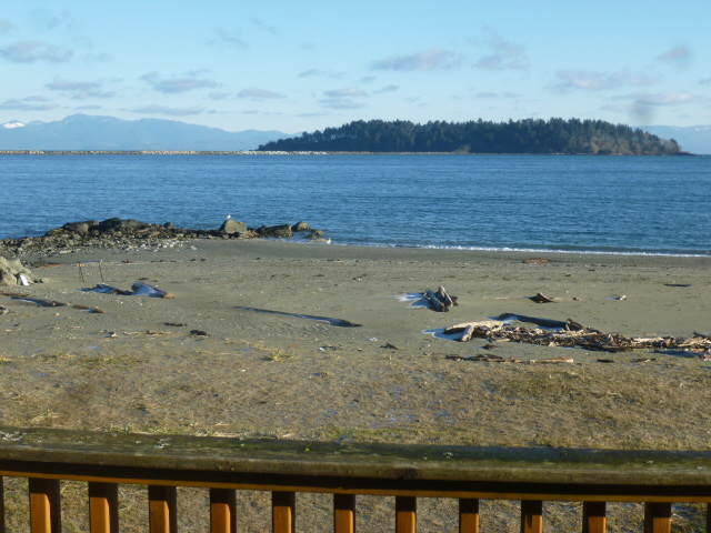
CANADA viewed from SENIOR CENTER "Front Porch" ... Near Island is in NEAH BAY.
We should be so lucky to while away our Senior Years.

Please say HELLO to our CHEFs "LU" and "LA VERN".
All folks pictured are one of the 1,200 MAKAW TRIBAL MEMBERS.

SENIORS receiving LUNCH, a daily Week-day Service.

Dining Room - Rogue Gallery
- Wall of Photographs -

TOTEM outside the Senior Center Greeting Hall.

View from Senior Center across NEAH BAY ... CANADA faintly visible in the distant Sea Mist.

6 Miles distant from the Village are MAKAW Beaches fronting the PACIFIC OCEAN ... available to Campers, RVers, and lucky folks who rent upscale modern Beach Front CABINS, fitted out with all amenities at $150.00 per night, kitchen included.
Pictured is a single CABIN, of which some two dozen are available.

CABIN View of AMERICA's most NORTHWEST point of Land, CAPE FLATERY.


MAKAW BEACH SHELTER ...

MAKAW BEACH SHELTER TOTEM POLE.

CAPE FLATERY is visible behind this MAKAW NATION BEACH Outlook.
* * * * * * * * * *
Having driven Highway 112 from NEAH BAY to PORT ANGELES, we parked overnight at WAL-MART;
Breakfast was enjoyed at MAC D's where we created this Blog Update.
In a few minutes, we will drive to HURRICANE Ridge located some 15 miles South of Town (Port Angeles). One of America's outstanding Outlooks, HURRICANE RIDGE dominates the mountain top NORTH BOUNDRY of the massive "BOWL" that makes up America's YOUNGEST Mountain Range.
"...THE OLYMPIC MOUNTAINS ..."
Complete with 10 living ICE GLACIERS, the OLYMPIC MOUNTAINS offer a magnificent partner filling the WASHINGTON STATE Western Distance to the PACIFIC OCEAN some 100 miles distant - as the CROW flies.
SUNSETS from SEATTLE - especially while dining in the incomparable SPACE NEEDLE ... as well as views from Oregon to the South and from CANADA to the North, OLYMPIC MOUNTAINS take up Center Stage.
Port Angeles is blessed today with a COLD but crystal clear Sky - so common in these parts, we should be presented with a special HURRICANE RIDGE Spectacular...
...which we shall share on tomorrow's Blog Update.

No comments:
Post a Comment